![]()
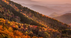
The graphic above is an averaged representation of fall color along the Blue Ridge Parkway. Read the full report below for specific milepost locations.
Where to Find the Best Fall Color on the Blue Ridge Parkway
Blue Ridge Parkway Daily’s “Fall Colors Tracker” is a great way to keep up with Autumn leaf changes. The Parkway stretches almost 500 miles north to south, meanders from the east- to west-facing slopes, and most importantly, varies in elevation from just under 650 feet at James River in Virginia to over 6,000 feet south of Mt. Pisgah in North Carolina.
Many visitors have been frustrated trying to go to one spot on one day in the fall, hoping to find the leaves in full color. A far better plan is to drive some distance on the Parkway, changing elevations and north-south orientation. Anyone who does this from the end of September until mid- to late-October will catch at least some of the pretty color that we’re famous for.
Also remember that weather conditions, like wind and rain, can accelerate the rate at which the leaves fall off the trees. Bad weather usually means that we lose our color quicker, so get out and see the color while it’s there.
Quick Summary – October 21, 2015
Past Peak (but offering long-range views of valleys below)
- Grandfather Mountain
- Craggy Gardens area
- Graveyard Fields
- Higher peaks of the Southern Region south of Mt Pisgah.
- Most elevations above 4,500′.
At Peak ( 75% & up )
- Boone / Blowing Rock area including Price Lake and Moses Cone Manor.
- Linn Cove Viaduct south to Crabtree Falls
- North of Asheville to Craggy Gardens
- South of Asheville to Mt Pisgah
- Most elevations in the range from 3,000′ to 4,500′.
Near Peak, but very colorful ( 50% to 75% ) <= THIS weekend’s (10/24-10/25) best outlook
- Most of the Parkway in Virginia
- North of Boone / Blowing Rock area traveling into Virginia.
- Asheville and the French Broad River Valley
- Valleys of the Southern region south of Mt Pisgah.
- Most elevations in the range from 2,000′ to 3,000′.
Patchy, but not green ( 10% – 50% )
- Roanoke & James River Areas
- Long range views off the eastern and western escarpment.
- Most elevations below 2,000′.
Complete details are in the full report below. As we get additional reports we will continue to update this page, so check back often. Really often.
Full Report Details – October 21, 2015
We’ve reached that time of year where the Blue Ridge Parkway experiences that much-anticipated change in fall foliage.
Virginia
Mileposts 29-45, Humpback Rocks to Montabello
In the northernmost part of the Parkway in Virginia, fall colors are rolling right along, with wonderful colors between mileposts 29 and 45. There are lots of yellows, golds, burnt oranges, and maroon reds. The drive between Humpback Rocks and Montabello is at peak or just slightly past, with the hickory, ash, sourwood, Virginia creeper, striped maple, and red maple species showing good peak colors.
North Carolina
Most of the color has shifted to lower elevations, but patches on some of the mountain summits are still quite colorful.
Mileposts 300-330
Between the Linn Cove Viaduct at milepost 304 and Flat Rock at milepost 308, the drive is full of vibrant red and oranges. The leaves are past their peak, but many trees are still holding on to their color.
At Linville Falls, the leaves are just past their peak, but there are still many maples and elms with yellow and red leaves.
Driving north from Chestoah Overlook at milepost 320, you can see the western rim of Linville Gorge. There, leaves are just past their peak, but you can still see numerous shades of yellow through the valley.
Mileposts 340-360
Driving from Crabtree Falls to Mt. Mitchell, the colors are still quite vibrant. The reds, yellows, and oranges are making their way into the valleys. The summits are past their peak, but leaves are at their peak just down the mountains.
Mileposts 360-469
Further south on the Parkway, there is still a fair amount of green at the lowest elevations, but most of the trees at the higher elevations have lost their leaves. Good color can be seen driving from Asheville towards Craggy Gardens and Pisgah areas. The colors are at peak in the 3,000 foot elevation range, with lots of yellows and golds and the reds of the oaks, sourwoods, and dogwoods providing a nice visual contrast.
Now, Submit Your Report
Other Fall Color Reports We Recommend
- Nationwide Fall Foliage Prediction Map
A national map that can be used to predict the timing of fall colors throughout the United States. Very useful tool for those wanting to plan trips to see fall leaf color. - Fall Color Forecaster Map at Appalachian State University
Slide the leaf along the dates at the bottom. As you move through the dates, the map will highlight those parts of the state coming into peak color, followed by a browning, which indicates they are past their peak. - Fall Color Guy at Appalachian State University
A page from ASU biology professor Howard Neufeld who posts a weekly report on western North Carolina. - Explore Asheville Visitor Center
The “Official Source” for the 2014 fall color forecast in Asheville and western North Carolina. - Fall Color in the Smokies
This is the official fall color site for Great Smoky Mountains National Park. It contains information about when and where to see fall colors in the Park. - Fall Color on Blue Ridge Parkway
A really great website for fall foliage color reports can be found at the Blue Ridge Parkway Guide by Virtual Blue Ridge. They update frequently, and have archived reports from the past and they cover the entire 470 miles of the Parkway. - The Foliage Network
This is a New England based fall foliage site that provides information on the progression of fall foliage color throughout the eastern, southern and midwestern United States. - Webcams of North Carolina
One way to see fall colors without actually driving somewhere is to view the many webcams that are situated throughout the state. This webpage has links to many webcams in western North Carolina, and in other states. Note that some cameras are of higher quality and provide a better image than others. Also, the time of day you view the webcams can affect your perception of the intensity of the fall colors. Nonetheless, this is a useful site. - Weekly Fall Color Reports for NC
Presented by the North Carolina Department of Commerce, Division of Tourism, Film and Sports Development.
Share The Blue Ridge Parkway Fall Colors Tracker On Your Site
Contact us for details on how to share the Fall Colors Tracker graphics on your site.